|
| |
|
This
web site is a resource for researchers of family tree
(genealogy)
and history in STRAFFORD County, New Hampshire.
HISTORY | DOCUMENTS
| OTHER AREAS OF RESEARCH
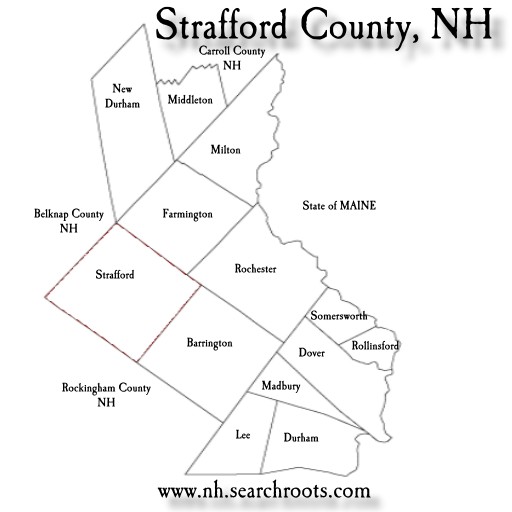
MAP OF STRAFFORD COUNTY | TOWNS/CITIES
IN STRAFFORD COUNTY
For
Help with Researching your family tree,
see HISTORY & GENEALOGY OF NH (Main Site)

BRIEF
HISTORY OF STRAFFORD CO., NEW HAMPSHIRE
Strafford
County was one of the five original counties identified
for New Hampshire in 1769. Strafford County was
organized by an act of the Colonial Legislature,
passed March 19, 1771, under the administration
of Governor John Wentworth, the then Province of
New Hampshire. The area was divided into five Counties,
named by him, after some of his friends in England--including
Strafford, being named after the Earl of Strafford,
who was a distinguished member of the Wentworth
family, Thomas
Wentworth, Earl of Strafford
The
areas now within Strafford County were originally
called Hilton's Point, Cocheco, Dover Point and
Dover Neck (depending on the locality). Strafford's
river and ocean access made it an ideal location
for sawmills and shipbuilding, two of the strong
industries in the 1600s. The County of Strafford
now consists of thirteen subdivisions as
follows: Barrington, Dover, Durham, Farmington,
Lee, Madbury, Middleton, Milton, New Durham, Rochester,
Rollinsford, Somersworth, and Strafford.
The
boundaries of Strafford have varied but little,
since it was originally erected into a County. The
towns of Holderness and Campton, which originally
belonged to Strafford, are now part of Grafton County.
The towns of Burton (now Albany), Chatham and Conway
who originally belonged to Grafton County are now
part of the territory of Strafford County.
In
consequence of the sparseness of the population
at the time of the division, it was provided, that
the Counties of Strafford and Grafton should remained
annexed to Rockinghma, until the Governor, with
advice of the Council, should declare them sufficient
for the exercise of their respective jurisdictions.
The County of Strafford remaiend so annexed until
about the beginning of the year 1773. The first
Court held in the County, under the new organization,
was the Court of General Sessions of the Peace,
which took place February 23, 1773.
Strafford
County is in the easterly part of New Hampshire,
bounding on the State of Maine about seventy miles.
It is bounded as follows: on the north by Carroll
County, on the east by York Co., Maine, on the south
by Rockingham County, and on the west by Rockingham
and Belknap Counties. It embraces a territory of
about 1,400 square imles and it contained, in 1775,
a population of 12,513. In 1830 it amounted to 58,916.
According to the 2000 federal census estimates it
has a population now of 112,233.
The
county is watered by the Lamprey, Bellamy, Cocheco,
Isinglass, and Salmon Falls Rivers, which furnish
an abundance of water-power.
The
City of Rochester is the largest city in the seacoast
region and is located in the middle of Strafford
County, being 40 miles east of Manchester NH. The
County Seat of Strafford is Dover, located
along the Cocheco River.
SOURCES:
--Juridical and other statistics of the county of
Strafford in the state of New Hampshire, by Francis
Cogswell; Boston: Printed by Perkins & Marvin,
1839.
--New Hampshire as it is by Edwin A. Charleton;
Claremont, N.H.; A. Kenney & Co.,, 1857
-- History of Rockingham and Strafford Counties,
New Hampshire : with biographical sketches of many
of its pioneers and prominent men; John Cutt, Richard
Cutt; Philadelphia: J.W. Lewis & Co., 1882.
-
There
is ONE covered bridge in Strafford County,
i.e.:
COCHECO
RIVER FOOTBRIDGE NH-09-02, Warren Truss, built
in 1996, was located on Washington Street, in Dover,
crossing the Cocheco River. It was put in storage
in 2010.The GPS location is Lat. 43.1952N &
Long. -70.8705W.
DOCUMENTS
(this site) for genealogical
research
OTHER
AREAS OF GENEALOGY / FAMILY TREE RESEARCH FOR STRAFFORD
COUNTY (this site)
- Genealogy
-
Online Book: BOOK: Revolutionary
Pensions in Strafford County NH-- (Internet
Archive). The names of American Revolution pensioners,
a description of their military service, and the
town where they resided at the time of the compilation.
>>>Daniel Woodman aka Martin (Durham),
Peter Akerman (Rochester), Joseph Bean (Gilmanton),
Sergt. James Burnham (Somersworth), Henry Buzzels
(Middleton), Maj. James Carr (Somersworth), Joseph
Daniels (Barrington), Daniel Davison (Guilford),
John Davis (New Durham), Benaiah Dore (Milton),
Abraham Drake (New Hampton), Moses Ferren (Eaton),
John Gage (Strafford Co. prob. Somersworth), John
Garlin (Wakefield), Capt. Benjamin Gilman (Tamworth),
Silvanus Hall (Tamworth), Ephram Ham (Dover), William
Twombly (Dover), Enoch Hayes (Tamworth), Lieut.
Thomas Hayes (Gilmanton), Nathaniel Havford (Tamworth),
John Holmes (Strafford), Israel Huckins (Barrington),
Solomon Hutchins (Wakefield), Amos Leavitt (New
Hampton), Jonathan Leavitt (Conway), Joseph Marsh
(Gilmanton), John Marston (? Location), Samuel martin
(Sandwich), Simeon Mason (NH), David Morrison (Alton),
Benjamin Morse (Moultonborough), Jonathan Morrison
(Tuftonborough), Edward B. Moulton (Moultonborough),
Reuben Moulton (?), George Nichols (Holderness),
David Page (Guilford), David Piper (Wolfeborough),
Reuber Ricker (Dover NH), Benjamin Roberts (Rochester
NH), James Sanborn (Strafford County), Reuben Sanderson
(Sandwich), Moses Senter (?), Benjamin Sleeper (Alton),
Edward Smith (Gilmanton), Henry Smith (Sanbornton),
Jeremiah Smith (Sanbornton), Joseph Smith (Sanbornton),
Eli Sumner (Rochester), Daniel Swett (Gilmanton),
William Taylor (Sanbornton), Ephraim Tebbets (Strafford
Co), David Thompson (Guilford), Samuel Thompson
(Sandwich), John B. Tilton (?), William Twombly
(Dover), John Wadleigh (Gilmanton), Nathaniel Wadleigh
(Meredith), Benjamin Wallace (Sandwich), Caesar
Wallace (Meredith), Weymouth Wallace (Sandwich),
Francis Walls (Durham), William Warren (Moultonboro),
Daniel Watson (Rochester), John Watson (Sandwich),
John Watson (Wakefield), Joseph Weed (Ossipee),
Stephen Webster (New Durham), Matthias Welch (Rochester),
Phineas Wentworth (Dover), Joseph White (Ossipee),
Jonathan Whitehorn (Alton), Silas White (Ossipee),
Andre Whittier (Guilford), Benjamin Wiggin (Tuftonborough),
Lt. Col. Mark Wiggin (Wolfeboro), Charles Willey
(Lee), Josiah Willey (Wolfboro), James Wilkinson
(Alton), Enoch Wingate (Milton), Elijah Witham (Rochester),
Nathan Witham (Meredith), Daniel Woodman (Durham),
Jeremiah Woodman (Alton), James Worcester (Alton),
Samuel Yeaton (Durham), Samuel York (Guilford),
Jonathan Young (Milton), Capt. Joseph Richardson
(Durham).
- 1790
US Census of Strafford County NH BY SURNAME -
Rays Place
-
Strafford
County Marriages - some fairly recent [with
search option]- Rootsweb
- Strafford
County NH Archives
- a
collection of wonderful FREE listings of tax lists,
deeds, wills, probate documents, war rolls, vital
records, local genealogy, town events, biographies,
genealogies, wedding announcements, anniversaries,
divorces, news articles, cemeteries, gazeteers and
books. (Please note: these are not all inclusive,
and only a SAMPLING of each). USGenWeb
- Strafford
County Cemeteries (limited) - USGenweb
- Researching
family trees in New Hampshire and Strafford
County
- American
Revolution Pensioners in 1840,
Strafford Co. - USGennet
- Cemetery:
Tombstone
Project for Strafford Co NH- USGenWeb
- NHGenWeb
- information about some cemeteries, gazeteers,
newspapers, obituaries and military pensions in
Coos County.
- Family
Tree: Peavey
Family of Strafford Co. NH - Rootsweb
- HISTORY
- Online
Book: History of Strafford County, New Hampshire,
and representative citizens - Scales, John, 1914
- Internet Archive
- Online
Book: History of Rockingham and Strafford counties,
New Hampshire : with biographical sketches of
many of its pioneers and prominent men - Hurd, D.
Hamilton, Philadelphia 1882- Internet Archive
- Historic
Places in Strafford County - National Register
of Historic Places
- Coos
County HISTORY
- Locate
a historical society in New Hampshire
- Biography:
John
Yeaton Scruton of Farmington & Strafford NH
(Biographical Sketches State of Maine - Google EBook)
- Biography:
New Hampshire: The
Origin of "Old Home Week" and the Rollins
Family [The Rollins family of Strafford Co.
NH] - Blog: Cow Hampshire
- Brief
Biographies and Obituaries
[from Granite State Monthly magazine, use SEARCH
to find them in publication] includes: FOSS
Family of Strafford, Barrington and Manchester NH;
Isaac Lougee of Rochester; William Hale, George
G. Lowell, George W. Ela, Samuel Crook Whiiter MD,
Hon. Frank N. Parsons, all of Dover NH; James F.
Joy of Durham, removed to Michigan; Hon. Alonzo
Nute of Milton and Farmington, and Ebenezer G. Wallace
of Farmington; Daniel J. Parsons and Ebenezer Wallace
of Rochester.
- Profile
& Statistics
- 1880
CENSUS, New Hampshire [free, online] (Volume
Reel 0769 - 1880 New Hampshire Federal Population
Census Schedules - Strafford County) - United
States. Bureau of the Census -- Internet Archive
- Research
- Photographs
- Business
- NEWS:
- MAPS
- MAP:
Outline
map of Strafford County (no town names)
- MAP:
Black
and white outline map of Strafford County NH with
town names -
- MAPS
(multiple): University of NH Digital Map Collections
- Hurd Town and City Atlas of 1892 (Barrington,
Dover, E. Rochester, Farmingham, Gonic, Great Falls,
Lee, Madbury, Middleton, Milton, New Durham, Rochester,
Rollinsford, Salmon Falls, Somersworth and Town
of Strafford), Historic USGS Maps of New England
1890s-1950s, 1878 Atlas from the Hitchcock Geology
of NH
|
|
|
|
|
|
|
|
|
|
| |
|
|
| |
|
Current communities in Strafford County include:
Barrington, Dover,
Durham, Farmington,
Lee, Madbury,
Middleton, Milton,
New Durham, Rochester,
Rollinsford, Somersworth,
and Strafford.
|
|
|
|
|
| |
|
|
|
TOWNS
/ CITIES IN STRAFFORD COUNTY, New Hampshire
BARRINGTON
- Brief
History: The town of Barrington was chartered by proclamation
in a document dated May 10, 1722 and signed by Samuel Shute,
Governor of the Province of New Hampshire. The population
of the town of Barrington, according to the census of 1790
was 2470. In 1800 it was 2773. In 1810 the population increased
to 3564. Of those prominent in the original settlement of
the town were William Cate, Hugh Montgomery, Sampson Babb,
Arthur Danielson, Paul Hayes, Eleazer Young, Mark Hunking,
Francis Winkley, Samuel Brewster, and Timothy Waterhouse.
- Villages
and Place Names: East Barrington, South Barrington,
West Barrington
- Profile
& Statistics of Barrington NH (current) PDF
- GOVERNMENT:
- OTHER
WEB SITES:
- Genealogy:
- Annual
Report of the Town of Barrington, New Hampshire for Years:
1891, 1893, 1928-29, 1933-34, 1934-35, 1935-36, 1936-37,
1937-38, 1938-39, 1939-40, 1940-41, 1941-42, 1942-43,
1943-44, 1944-45, 1945-46, 1946-47, 1947-48, 1948, 1949,
1950, 1951, 1952, 1953, 1954, 1955, 1956, 1957, 1958,
1959, 1960, 1961, 1962, 1963, 1964, 1965, 1966, 1968,
1969, 1970, 1971, 1972, 1973, 1974, 1975, 1976, 1977,
1978, 1979, 1980, 1981, 1982, 1983, 1984, 1985, 1986,
1987, 1988, 1989, 1990, 1991, 1992, 1993, 1994, 1995,
1996, 1997, 1998, 1999, 2000, 2001, 2002, 2003, 2004,
2005, 2006, 2007,Annual Reports for the Town of Barrington
NH (These include births, marriages and deaths for that
year at the end of the report). -- Internet Archive
- Brief
History of Barrington NH from: The New England gazetteer
containing descriptions of all the states, counties and
towns in New England; 14th ed.; published 1841 by I. S.
Boyd and W. White, J. Hayward in Concord, N.H, Boston.
- Strafford
County Archives
-
USGenWeb
- Strafford
County NH -
USGenWeb
- Frank
Jones & the Frank Jones Brewery
- Barrington
Historical Society
Address: c/o E Hayes, Treasurer
169 Route 9
Barrington , NH 03825-3829
Phone: 603-664-2442
Email: pjm@metrocast.net
Business:
Photographs/Postcards:
- General
Photographs of Barrington NH - Flickr
- Winkley's
Pond, in Barrington NH (Wikipedia)
- East
Barrington NH Post Office,
vintage (Wikipedia)
- Photograph
Collection: several
early (1900-1950's) photographs of Barrington, Dover,
Durham, Farmington, and Rochester NH
- Barrington:
Photograph - Frank
Jones (1832-1902), b. in Barrington NH, Sep 15, 1832,
son of Thomas Jones, moved to Portsmouth NH when 17 years
old; died in Portsmouth Oct 2, 1902, buried in Harmony Grove
Cemetery; married Sept 15, 1861 to Martha Sophia Leavitt,
the widow of his brother, Hiram Jones; was
a successful businessman and politician. He was the
mayor of Portsmouth, New Hampshire and a United States representative
(1875-1879). His many business ventures included the Frank
Jones Brewing Company, hotels, an insurance firm, a shoe
factory, the Maine and Boston railroad, a music hall, racehorses
and three utilities. Had at least 2 daughters, Eliza, and
Emma J.
MAPS:
- Barrington
and surrounding area map - Topographical
- University
of NH Digital Map Collections - Hurd Town and City Atlas
of 1892 (Barrington, Dover, E. Rochester, Farmingham,
Gonic, Great Falls, Lee, Madbury, Middleton, Milton, New
Durham, Rochester, Rollinsford, Salmon Falls, Somersworth
and Town of Strafford
- Yahoo
map and driving directions to Barrington, NH
DOVER
- Brief
Early History: New Hampshire history begins in Dover.
The Indian name of the place was Wecohamet. Settled in 1623
on the banks of the Piscataqua River, it was the first permanent
settlement in New Hampshire and the seventh oldest in the
United States. Dover is therefore the oldest town in the
state, having been settled only three years after the landing
of the Pilgrims at Plymouth, Mass. and nine years after
the discovery of New Hampshire, by Captain Smith. [Portsmouth
was settled about the same time, at a place called Little
Harbour by David Thompson, who came over with the Hiltons.
There is ongoing discussion with Portsmouth historians of
which is oldest settlement - Dover feels it is definitely
because it was never abandoned!] Edward and Wm. Hilton were
sent by "The Company of Laconia," and it was first
called Hilton's Point. Captain Thomas Wiggins became the
agent for the proprietors. Dover manufacturers were pioneers
in large-scale printing of cotton fabric in the 1820s. Dover’s
first mill was built in 1815 on the Upper Falls of the Cocheco
River. The Cocheco Manufacturing Company was incorporated
in 1827, and discontinued all operations in 1937. Dover
was incorporated as a city in 1855.
- Villages
and Place Names of Dover NH: Bellamy, Cocheco, Gates
Corner, Sawyers, Wentworth Terrace.
- Profile
& Statistics of Dover NH (current)
- GOVERNMENT:
- OTHER
WEB SITES:
- Genealogy:
- History
& Genelaogy of Dover and Old Dover, New Hampshire
(compiled from various sources) -- (this
site) - TXT
File | PDF
file | RTF
File
- Online
Book: History
of the Town of Dover, Strafford Co. NH - from History
of Strafford County, New Hampshire, and representative
citizens - Scales, John, 1914
- FREE
ONLINE: Old Book of Marriages, Births and Deaths 1693-1838
/ Early Reocrds of NH Families / Rev. John Pikes List
of Marraiges 1686-1709 / Rev. Jonathan Cushings Record
of Baptisms 1717-1766 / Rev. Dr. Jeremy Belknap's Records
of Baptisms 1767-1786 / Rev. Dr. Jeremy Belknap's Records
of Marriages 1767-1776 / Rev. Joseph W. Clary's Record
of marriages, 1812 -1829 / Rev. Hubbard Winslow's Records
of Marriages 1829-1831 / Nathaniel Cooper's Records
of Death's 1773-1791 / Dea. Benjamin Peirce's Records
of Deaths 1792-1802 / List of Members of First Church
1718-1850 / Baptisms by Rev. Robert Gray, 1787-1800
/ Marriages from Methodist Church Records, 1835-1850
/ Marriages from Episcopal Church Records 1839-1850
/ Marriages from Unitarian Church 1829-1850 / Marriages
from Catholic Church Records, 1843-1850 / Index of Persons
-- Collections of the Dover NH Historical Society, Vol.
1, Dover, Scales & Quimby, 1891 -- Internet Archive
- Online
Database - at Dover (NH) Public Library - searchable
- High School yearbooks (1915-2013), and City DIrectories
(various from 1830-1956.
- Online
Book: Dover
Tax Rate List 1648; NH Genealogical Record; Vol
I, July 1903-April 1904
- Friends
Records [Quakers] Dover N.H. Monthly Meeting:
MARRIAGES 1701-1775.[from The New Hampshire Genealogical
Record, October 1903, Vol 1, No. 2]
- Friends
Records [Quakers] Dover NH. Monthly Meetings MARRIAGES,
contd. 1776-1799 [from The New Hampshire Genealogical
Record, January 1904, Vol 1, No. 3].
- Friends
Records [Quakers] Dover NH Monthly Meetings MARRIAGES
(cont'd) 1800-1843
- Online
Book: Friends Records, Dover NH Monthly Meetings; Marriages
from 1776 to 1799; NH Genealogical Record.
- Online
Book: Friends Records, Dover NH Monthly Meetings; Marriages
from 6 Feb 1800 to 2 February 1843; NH Genealogical
Record; Vol I, July 1903-April 1904
- Friends
Records, Dover NH Monthly Meetings (Quaker)
[continued from Vol V, page 176] , from The New Hampshire
genealogical record : Vol VI, January 1909-October 1909
- Friends
Records, Dover, N.H. Monthly Meeting (Quaker), Family
Records; 1790-1857 [Continued from Vol VI, page
25], from The New Hampshire genealogical record : Vol
VI, January 1909-October 1909
- Friends
Records, Dover NH Monthly Meetings (Quakers), Family
Records, continued 1753-1869,
from The New Hampshire genealogical record; Vol VI,
January 1909-October 1909
- Friends
Records, Dover NH, Monthly Meeting (Quaker), Family
Records, 1815-1871,
from The New Hampshire genealogical record; Vol VI,
January 1909-October 1909
-
Friends Records, Dover NH, Monthly Meeting (Quaker),
Family Records, 1812-1869 by The New Hampshire genealogical
record; Vol VI, January 1909-October 1909,
- Friends
Records, Dover NH, Monthly Meeting (Quakers) continued,
1768-1864,
from The New Hampshire genealogical record; Vol VI,
January 1909-October 1909
- Inscriptions
from the Waldron Cemetery, Dover New Hampshire,
from The New Hampshire genealogical record; Vol VI,
January 1909-October 1909
- Receipts
and Expenditures of the Town of Dover NH (NOTE:
Births, Marriages and Deaths listed in the BACK of each
booklet) - (The Year Shown will display vital
records for the prior year) YEARS: [1849]
[1850]
[1852]
[1853]
[1854]
[1856]
[1858]
[1859]
[1860]
[1861]
[1862]
[1863]
[1864]
[1865]
[1866]
[1868]
[1869]
[1870]
[1872x2]
[1872]
[1873]
[1874]
[1875]
[1876]
[1877]
[1878]
[1879]
[1880]
[1881]
[1882]
[1883]
[1884]
[1885]
[1886]
[1887]
[1888]
[1890]
[1891]
[1892]
[1893]
[1894]
[1895]
[1896]
[1897]
[1898]
[1899]
[1900]
[1901]
[1902]
[1903]
[1904]
[1905]
[1906]
[1907]
[1908]
[1909]
[1911]
[1912]
[1913]
[1914]
[1915]
[1916]
[1917]
[1918]
[1919]
[1920]
[1921]
[1922]
[1923]
[1924]
[1925]
[1926]
[1927]
[1928]
[1929]
[1930]
[1931]
[1932]
[1933]
[1935]
[1936]
[1937]
[1938]
[1939]
[1940]
[1941]
[1942]
[1944]
[1945]
[1946]
[1947]
[1948]
[1949]
[1950]
[1951]
[1952]
[1954]
[1955]
[1956]
[1957]
[1958]
- Internet Archive
- Online
Book: Persons and Places of Old Dover by John Scales,
Dover NH, March 1900- Internet Archive
- Brief
History of Dover, NH from: The New England gazetteer
containing descriptions of all the states, counties
and towns in New England; 14th ed.; published 1841 by
I. S. Boyd and W. White, J. Hayward in Concord, N.H,
Boston.
- Notable
events in the history of Dover, New Hampshire,
from the first settlement in 1623 to 1865 - Wadleigh,
George - Internet Archive
- Old
Dover, New Hampshire, by Caroline Harwood Garland;
The New England magazine; Volume 23, Issue 1; Sept 1897
- Historical
Sketch of Dover NH's Participation in the Spanish-American
War,
compiled by Fred E. Quimby, City Clerk, 1928
- Richard
Hussey and his Descendants of Dover NH, from The
New Hampshire genealogical record; Vol VI, January 1909-October
1909
- Correction
re daughters of Timothy and Elizabeth Hussey of Dover
NH. Mary (not Hannah) married Thomas Snell. Hannah
married Joseph Whitney, from The New Hampshire genealogical
record : an illustrated quarterly magazine devoted to
genealogy, history, and biography : official organ of
the New Hampshire Genealogical Society, Vol VI, January
1909-October 1909
- The
Rev.Hugh Adams and Family,
from The New Hampshire genealogical record : an illustrated
quarterly magazine devoted to genealogy, history, and
biography : official organ of the New Hampshire Genealogical
Society, Vol VI, January 1909-October 1909
- Thomas
Downes of Dover NH and His Descendants,
from The New Hampshire genealogical record; Vol VI,
January 1909-October 1909
- Dover
New Hampshire
Preacher and Historian - Rev. Jeremiah "Jeremy"
Belknap, D.D. (1744-1798) - Blog: Cow Hampshire
- Biography:
Dover New Hampshire Artist,
Ruth (Whittier) Shute (1803-1882) - Blog: Cow
Hampshire
- Sketch
of Dover - from official Web Site
- History
of Dover,
chapter from History of Strafford Co. NH - Internet
Archives
- The
First parish in Dover, New Hampshire
- Dover, N.H. First parish. -- Internet Archive
- Landmarks
of Ancient Dover, NH
by Mary P. Thompson, Durham NH 1892 - Internet Archive
- The
first parish in Dover, New Hampshire : two hundred
and fiftieth anniversary, October 28, 1883 - Internet
Archive
-
Consecration of the Peirce Memorial Church, Dover, N.
H.,
January 11, 1883 - First Universalist Society (Dover,
N.H.) - Internet Archive
- The
First Parish in Dover, New Hampshire: Two Hundred and
Fiftieth Anniversary,
October 28, 1883 - First Parish Church (Dover, N.H.),
Alonzo Hall Quint - Internet Archive
- The
Dover pulpit during the Revolutionary War : a discourse
commemorative of the distinguished service rendered
by Rev. Jeremy Belknap, D.D., to the cause of American
independence - Spalding, George B. (George Burley),
1835-1914
- Dover,
New Hampshire; its history and industries descriptive
of the city and its manufacturing and business interests.
Issued as an illustrated souvenir in commemoration of
the twenty-fifth anniversary of Foster's Daily Democrat,
1898 - Internet Archive
- The
remarkable captivity and surprising deliverance of Elizabeth
Hanson
: wife of John Hanson of Knoxmarsh, at Kecheachy in
Dover township, who was taken captive with her children
and maid-servant by the Indians in New-England in the
year 1724 ... the substance of which was taken from
her own mouth - Hanson, Elizabeth, 1684-1737
- Journal
of Rev. John Pike, born 15 May 1653 at Salisbury
MA, son of Hon. Robert Pike. He removed to Dover NH
in 1678 for the work of the ministry. He also lived
in Portsmouth, Hampton, Newbury, and back to Dover.
From Collections of the New Hampshire Historical Society,
Volume III (1832).
- True
stories of New England captives carried to Canada
during the old French and Indian wars - Baker, Charlotte
Alice, 1833-1909 -- Christine Otis [Dover, N.H., 1689]--Esther
Wheelwright [Wells, Me., 1703]--Story of a York family
[John Sayward's, 1692]--Difficulties and dangers in
the settlement of a frontier town 1670 [Deerfield, Mass.]--Eunice
Williams [Deerfield, 1704]--Ensign John Sheldon [Deerfield,
1704]--My hunt for the captives.--Two captives [Abigail
Nims and Josiah Rising, Deerfield, 1704]--A day at Oka
[Canada]--Thankful Stebbins [Deerfield, Mass., 1704]--A
scion of the church in Deerfield... - Internet Archive
- Biography:
The
Leading business men of Dover, Rochester, Farmington,
Great Falls and Berwick, illustrated, Bacon, George
F. (George Fox), 1890, Boston, Mercantile Publishing
Company - Internet Archive. Business Men of Dover NH
include: Merrimac Manufacturing Co., G.H. Churbuck,
George Dunn; Lothrop, Farnham & Co., A.E. parker,
Pattee Brothers, William A. Morrill, Dover National
Bank, J. Frank Seavey & Co.; Killoren Brothers,
C.W. Smith, M.W. Courser, B. Frank Nealley, William
H. Vickery; Grimes' Cream Bread, Cake and Pastry; O.F.
Kimball; William Sterns & Co., A.W. hayes; J.W.
Foss & Co., Andrew S. Hall; Dover Five Cents Savings
Bank; Dover Beef Co., George W. Hayes, Meserve Agent
Millinery Goods; Sawyer Woolen Mills; C.H. Trickey &
Co., Rich & Higgins [John R. Higgins]; Littlefield,
Frary & Co. [S.H. Fuller, H. Littlefield, Fred D.
Frary, George L. Johnson]; John T.W. Ham; E.S. Tash
& Co.; Charles A. Tufts; B F. Rackley; C.E. Bacon;
R.H. & H. O. Woodberry; M. Killoren & Co., Eben
C. Barry; J. Dondero & Co., W.E. Browne, Browne
& Stevens; I.B. Williams & Sons; A.N. Ward;
Strafford National Bank; C.E. Marston; Henry C. Goodwin;
Frank C. Snow & Co.; The Hawthorne; Husty Brothers;
D.C. M. Pierce; George A. Reynolds; George F. Nute &
Co.; Sullivan & Littlefield; F.C. Tilton; Cushing
& Delaney; B.F. Kennard; Eugene Smart; John P. Lowell;
Walter T. Perkins; W.S. Wiggins; Atlantic Tea Company;
J.H. Winslow; New Hampshire House; R.H. Twombly; Charles
Emerson & Sons; E.V. Brewster & Co., A.J. Young
D.D.S.; George H. Bradbury, Howes & Ford; Charles
W. Wiggin & Son; C.T. Henderson; H.E. Canney; Dover
Steam Laundry.
- A
bill of mortality for the Society of Friends, in Dover,
N.H.,
from 1708, to 1791 (List of deaths) - Internet Archive
- Historical
Memoranda, Persons and Places in Old Dover NH
- John Scales, Dover NH March 1900 - Internet Archive
- Journal
of the Rev. John Pike, of Dover, N. H
- Pike, John, 1653-1710. - Internet Archive
- Dover
NH Physicians,
June 17, 1879, Concord NH - Internet Archives
- Thomas
(Nock) Knox of Dover, N.H., in 1652
: and some of his descendants - Lapham, William Berry,
1828-1894 - Internet Archive
- Richard
Pinkham of old Dover, New Hampshire and his descendants
East and West - Sinnett, Charles N.- Internet Archive
- The
Kimballs of Dover (NH) -
reprinted from the Dover Enquirer of 1883 - Internet
Archive
- John
Waldron, of Dover, N.H.
and his descendants - Internet Archive
- Dover
NH - Historical
Sketch of Dover's Participation in the Spanish-American
War 1898, compiled by Fred Quimby, City Clerk -
Internet Archive
-
89th anniversary of the national independence, July
4, 1865,
at Dover, N.H - Dover (N.H.) - Internet Archive
- Roster
- NH Division of Sons of (Union) Veterans, USA,
1891, 1892 - Internet Archive
- Online
Book: Deacon
Samuel Haines of Westbury, Wiltshire, England, and
his descendants in America, 1635-1901 - Haines, Thomas
Vanburen; 1902
PHOTOGRAPHS:
- Photograph:
Flickr
Photographs of Dover NH
- Photographs:
Historic
Photographs of Dover NH - Dover NH Public Library
- Old
Scrapbook of Dover NH
- from seacoastnh.com
- Birds
Eye View of Dover NH 1877
- American Memory
- Historic
Building: DOVER, Colonel
Alexander Scammell Memorial Bridge, Spanning Bellamy
River at U.S. Route 4 - American Memory/HABS
- Images
of the Past
- Dover-Rochester NH Collection
- Sawyer
Woolen Mills, Dover NH -
NH Historical Society
- Lucy
Lambert Hale - daughter of New Hampshire Senator John
Parker Hale of Dover, NH, she was also the fiancee of John
Wilkes Booth. This photograph was found on his body.
Sometime in late 1864 or early 1865, Booth
entered into a serious romance with Lucy. In January
of 1865 the Hales moved into the National Hotel where Booth
was staying. (President Lincoln named John Hale to be minister
to Spain, and the Hale family was making preparations to
sail to Europe). By March Booth was secretly engaged to
Lucy Hale. On March 4th Booth attended Lincoln's second
inauguration as the invited guest of Lucy. Booth is known
to have confided to his actor friend Samuel Knapp Chester,
"What an excellent chance I had to kill the President,
if I had wished, on inauguration day!" Booth was seen
with Lucy at the National Hotel on the morning of the assassination.
- Photograph
Collection: several
early (1900-1950's) photographs of Barrington, Dover,
Durham, Farmington, and Rochester NH
- Lithograph:
DOVER,
Birds Eye View 1877 - American Memory/HABS
MAPS:
- University
of NH Digital Map Collections - Hurd Town and City Atlas
of 1892 (Barrington, Dover, E. Rochester, Farmingham,
Gonic, Great Falls, Lee, Madbury, Middleton, Milton, New
Durham, Rochester, Rollinsford, Salmon Falls, Somersworth
and Town of Strafford
- Topographical
Map of Dover NH
- Yahoo
Map: Dover NH
DURHAM
- Brief
History of Durham NH: Incorporated 15 May 1732. Durham
started as a parish of Dover called Oyster River Plantation,
first settled in 1669. The river takes its name from the
abundance of oysters formerly found near its confluence
with the Piscataqua. [There are two varying stories on the
origin of its name, i.e. 1) is named after Durham, County
Durham, England, from whence came two of its earliest settlers,
William and Henry Hilton or 2) Durham was incorporated in
1732, probably to honor the first Puritan bishop, Richard
Barnes, Bishop of Durham.] Durham included what is now Lee
until 1766, when that town was incorporated. Benjamin Thompson,
descendent of an early settler, bequeathed the family estate,
the Warner Farm, to be used for establishment of an agricultural
college. The state agricultural school, originally set up
in Hanover in 1866, was moved to Durham in 1890, becoming
the University of New Hampshire in 1923.
Villages
and Place Names:
Northam, Oyster River
GOVERNMENT:
PROFILE
& STATISTICS:
GENEALOGY
& HISTORY:
- History
& Genealogy:
History of Durham, N.H. (this site)
- TXT
File | PDF
File | RTF
File
- Online
Books: Receipts
and expenditures of the town of Durham (NH) including vital
statistics, births, marriages and deaths for the years:
1847, 1852, 1854-1856 1858-1877, 1879, 1880, 1882-1887,
1889-1941, 1943-1998, 1999-2007
- Online
Book: Genealogical Records of Durham, Births
Marriages and Deaths, part 1 (1700s)
- Online
Book: Genealogical Records of Durham, Births
Marriages and Deaths, Part 2 (1700s, 1800s); NH Genealogical
Record; Vol I, July 1903-April 1904
- Online
Book: History
of the Town of Durham, Strafford Co. NH - from History
of Strafford County, New Hampshire, and representative citizens
- Scales, John, 1914
- Online
Books: Receipts
and expenditures of the town of Durham NH, varied; between
the years 1846-2006; including vital statistics, births,
marriages and deaths - Internet Archive
- Online
Book: The History of the Town of Durham, New Hampshire
(Oyster River Plantation) with genealogical notes, by Everett
Schermerhorn Stackpole, Lucien Thompson and Winthrop Smith
Meserve, 1913 -- // Volume
One Narrative // Volume
Two Genealogical
- Article:
Durham
Fire Department History - from the official Durham NH
web site
- Online
Book: Brief
History of Durham NH from: The New England gazetteer
containing descriptions of all the states, counties and
towns in New England; 14th ed.; published 1841 by I. S.
Boyd and W. White, J. Hayward in Concord, N.H, Boston.
- Article:
"New
Hampshire Missing Places: The Rocking Stone of Durham"
- from Blog: Cow Hampshire
- History
of Durham, NH - Wikipedia
- Online
Book: The
Durham pageant - Durham (N.H.), 1917; An Out-door Drama
Presented by the People of the Town and of New Hampshire
College, in celebration of the Hundredth Anniversary of
the Durham Congregational Church
- List
of Documents in special collections relating to Durham
NH Town Records (UNH)
HISTORY
and DOCUMENTS relating to UNIVERSITY OF NEW HAMPSHIRE (and
precursors):
- Online
Book: The New Hampshire College of Agriculture and Mechanic
Arts Bulletin, Durham NH [includes map, faculty, historical
sketch, general information (detail of the college and scholarships),
registration, building and equipment, halls, four year course
descriptions, entrance requirements, requirements for degrees,
courses of study, description of studies, Two year course
in agriculture: description of studies; two-year course
in elementary industrial engineering, description of studies;
Winter short Courses in Agriculture; DEGREES AND HONORS
- (graduates), Roster of Regiment, List of Students FOR
YEARS: 1914
| 1915
| 1916
| 1917
| 1918
| 1919
| 1920
| 1921
| 1922
| 1923
| 1924
| 1925
| 1927
| 1928
| 1929
| 1930
| 1931
| 1932
| 1933
| 1934
| 1935
| 1936
| 1937
| 1938
| 1939
| 1940
| 1941
|
- Online
Book: 1933-1934
| 1939
| January
1954 | 1956
| Bulletin
of the University of New Hampshire, December 1957 |
1961-1962
| 1962
| Calendar, General Information, Student Life on Campus,
Methods of Admission, Expenses at New Hampshire, Map of
the Campus, Financial Aid for Students, the Programs of
Study.
The Graduate School 1967-1968 | 1968-1969
| The
Graduate School February 1971-1972 | 1972-1973
|
- Online
Book: Undergraduate Catalog, UNH: 1973-1974
| 1975-1976
| 1978-1979
| 1982-83
|
PHOTOGRAPHS:
- Photographs:
Town
Pound, Route 108, Durham NH - American Memory
- Photographs:
Ebenezer
Smith House, 20 Main Street, Durham NH - American Memory
- Photographs:
Town
Hall, Newmarket & Dover Roads, Durham NH - American
Memory
- Photographs:
Pendergast
Garrison, Packers Falls, Durham NH vicinity - American
Memory
- Photographs:
General
John Sullivan House, Newmarket Road, Durham NH - American
Memory
- Photographs:
Woodman
Garrison, Garrison Avenue, Durham NH - American Memory
- Assorted
Durham
NH Photographs - Flicker
- Photograph
Collection: several
early (1900-1950's) photographs of Barrington, Dover,
Durham, Farmington, and Rochester NH
- Historic
Structure: DURHAM,
Durham Falls Bridge, Spanning Oyster River at State
Route 108 - American Memory/HABS
BUSINESS:
MAPS:
- University
of NH Digital Map Collections - Hurd Town and City Atlas
of 1892 (Barrington, Dover, E. Rochester, Farmingham,
Gonic, Great Falls, Lee, Madbury, Middleton, Milton, New
Durham, Rochester, Rollinsford, Salmon Falls, Somersworth
and Town of Strafford
- Google
Map & Driving Directions to Durham NH
- Aerial
View of Durham NH
- Google Maps
FARMINGTON
History:
The town now known as Farmington was originally the West Parish,
a portion of Rochester. It separated from Rochester in 1798
as Farmington. It was also known as Farmington Dock because
its location on the Cocheco River was an ideal spot for sawmills.
Shoe-making factories became the manufacturing focus of the
town, and one of the first places to use automated shoe-making
machines instead of relying on handwork. One Farmington resident
known in the shoe trade was Jeremiah J. Colbath, who, after
changing his name to Henry Wilson, was elected Vice-President
under Ulysses S. Grant.
Villages
and Place Names: West Parish, Merrill's Corners, Robert's
Hill; March's Dock, Farmington Dock, The Dock.
PROFILE
& STATISTICS
GOVERNMENT:
GENEALOGY
& HISTORY:
- History
& Genealogy:
History of Farmington, N.H. (this
site) - TXT
File | PDF
File | RTF
File
- Online
Books: Annual
reports of the Town of Farmington, New Hampshire; including
vital records, births, marriages and deaths for years: 1896-1897,
1925-1927, 1935-1941, 1944-1949, 1951-1958, 1949-2003, 2005,
2008
- Online
Book: Brief
History of Farmington NH from: The New England gazetteer
containing descriptions of all the states, counties and
towns in New England; 14th ed.; published 1841 by I. S.
Boyd and W. White, J. Hayward in Concord, N.H, Boston.
- Article:
Farmington
New Hampshire Vice President of the United States: Jeremiah
Jones Colbath, aka Henry Wilson (1812-1874)
- Blog: Cow Hampshire
- Online
Book: History
of the Town of Farmington, Strafford Co. NH - from History
of Strafford County, New Hampshire, and representative citizens
- Scales, John, 1914
- Online
Book: The
town register Farmington, Milton, Wakefield, Middleton,
Brookfield, 1907-8
- Online
Book: Historical
Sketch of Farmington NH from The Leading business men
of Dover, Rochester, Farmington, Great Falls and Berwick,
illustrated, Bacon, George F. (George Fox), 1890, Boston,
Mercantile Publishing Company - Internet Archive
- Online
Book: Genealogy
of the Wheatley or Wheatleigh family. A history of the
family in England and America .. - Wheatley, Hannibal Parish;
1902
- Brief
History of Farmington NH - from town's official web
site
- Farmington,
New Hampshire - from Wikipedia
PHOTOGRAPHS:
MAPS:
- University
of NH Digital Map Collections - Hurd Town and City Atlas
of 1892 (Barrington, Dover, E. Rochester, Farmingham,
Gonic, Great Falls, Lee, Madbury, Middleton, Milton, New
Durham, Rochester, Rollinsford, Salmon Falls, Somersworth
and Town of Strafford
- Google
Map and Directions to Farmington NH
LEE
History:
Lee was incorporated on January 16, 1766. The territory of
Lee was part of the old town of Dover, which began to be settled
at Dover Point in the spring of 1623. The first immigrants
built their village on Dover Neck, and later branched out.
In 1669 a grant was made for "Wadleigh's Falls"
on the Lamperele River. In 1732 Durham separated from Dover,
and included the area that is now the town of Lee. It remained
a part of Durham until January 16, 1766 when the act for a
new town became law. Possibly the town was named for the town
of Lee on the River Lee, now in greater London, or another
belief it that it was named for General Charles Lee, friend
and kin of the Governor, who had fought with George Washington
and others during the French and Indian Wars. Lee also fought
under Washington during the American Revolution, and in doing
so, forfeited estates in England.
Villages
and Place Names: Glenmere, Lee Five Corners, South Lee,
Wadleigh Falls, Thompson's Falls, Newtown Plains, Lee Hill
aka "The Hill."
GOVERNMENT:
PROFILE
& STATISTICS
GENEALOGY
& HISTORY of LEE, NEW HAMPSHIRE:
- History
& Genealogy:
History of Lee, N.H. (this site) -
TXT
File | PDF
File
- Online
Books: Annual Reports of the Selectmen, Treasurer,
Highway Agents and Board of Education and Vital Statistics
(births, marriages, deaths) of the Town of Lee, N.H.
for various years including [1865]
[1879]
[1880]
[1881]
[1882]
[1883]
[1884]
[1885]
[1886]
[1887]
[1888]
[1889]
[1890]
[1891]
[1892]
[1893]
[1894]
[1895]
[1896]
[1897]
[1898]
[1899]
[1900]
[1901]
[1902]
[1903]
[1904]
[1905]
[1906]
[1908]
[1909]
[1910]
[1911]
[1912]
[1913]
[1914]
[1915]
[1916]
[1917]
[1918]
[1919]
[1920]
[1921]
[1922]
[1923]
[1924]
[1925]
[1926]
[1927]
[1928]
[1929]
[1930]
[1931]
[1932]
[1933]
[1934]
[1935]
[1936]
[1937]
[1938]
[1939]
[1940]
[1941]
[1942]
[1943]
[1944]
[1945]
[1946]
[1947]
[1948]
[1949]
[1950]
[1951]
[1952]
[1953]
[1955]
[1956]
[1957]
[1958]
[1959]
[1960]
[1961]
[1962]
[1963]
[1964]
[1965]
[1966]
[1967]
[1968]
[1969]
[1970]
[1971]
[1972]
[1973]
[1974]
[1975]
[1976]
[1977]
[1978]
[1979]
[1980]
[1981]
[1982]
[1983]
[1984]
[1985]
[1986]
[1987]
[1988]
[1989]
[1990]
[1991]
[1992]
[1993]
[1994]
[1995]
[1996]
[1997]
[1998]
[1999]
[2000]
[2001]
[2002]
[2003]
[2004]
[2005]
[2006]
[2007]
- Online
Books: Report of the superintending school committee of
the Town of Lee, N.H. for the year ending . - Lee (N.H.
: Town) - For years: [1863]
[1864]
[1866]
[1867]
[1871]
[1873]
[1876]
[1877]
- Online
Book: History
of the Town of Lee, Strafford Co. NH - from History
of Strafford County, New Hampshire, and representative citizens
- Scales, John, 1914
- Online
Book: Brief
History of Lee, NH from: The New England gazetteer containing
descriptions of all the states, counties and towns in New
England; 14th ed.;published 1841 by I. S. Boyd and W. White,
J. Hayward in Concord, N.H, Boston.
- Online
Book: Old
home week, Lee, New Hampshire, August 23, 1916 : two
hundred and fiftieth anniversary of settlement of the territory
: one hundred and fiftieth anniversary of incorporation
of the town - Scales, John, 1916
- Old
home week, Lee, New Hampshire, August 23, 1916 : two
hundred and fiftieth anniversary of settlement of the territory
: one hundred and fiftieth anniversary of incorporation
of the town - Scales, John
- Brief
History of Lee, NH - Rays Place
NEWS:
PHOTOGRAPHS:
BUSINESS:
MAPS:
- University
of NH Digital Map Collections - Hurd Town and City Atlas
of 1892 (Barrington, Dover, E. Rochester, Farmingham,
Gonic, Great Falls, Lee, Madbury, Middleton, Milton, New
Durham, Rochester, Rollinsford, Salmon Falls, Somersworth
and Town of Strafford
- Google
map and driving directions to Lee, NH
MADBURY
History:
Incorporated in 1755, Madbury was a part of Dover and Durham
that was sometimes called Barbados because many residents
were traders with the island. Also located here was the farm
of Sir Francis Champernowne of Greenland, nephew to Sir Ferdinando
Gorges, who at one time held proprietary rights to what is
now the state of Maine. Sir Francis' English home was called
Modbury, and the name Madbury is in its honor. Madbury Parish
was granted for the first time in 1755, and town privileges
were granted in 1768. The name Barbados is still used for
several natural features of the area, including Barbados Pond.
Villages
and Place Names: Madberry, Moharimet's Hill.
GOVERNMENT:
PROFILE
& STATISTICS
GENEALOGY
& HISTORY
- History
& Genealogy:
History of Madbury, N.H. (this site)
- TXT
File | PDF
File
- Online
Books: Receipts
and expenditures of the Town of Madbury, SOME include
Vital records, births, marriages and deaths for the years:
1853-1854,
1864, 1877, 1882-1884, 1886-1887, 1889, 1903, 1908-1914,
1916-1917, 1920-1921, 1923-1925, 1927-1928, 1930-1972, 1974,
1976-1990, 1992, 1994-1997, 1993, 1998-2007.(Internet Archives)
- Online
Book: History of the Town
of Madbury, Strafford Co. NH - from History of Strafford
County, New Hampshire, and representative citizens - Scales,
John, 1914
- Online
Books: Receipts
and expenditures of the Town of Madbury NH, MOST (but
not all) of which include vital records (births, marriages,
deaths) - of the following years: 1853-1854, 1864, 1877,
1882-1884, 1886-1887, 1889, 1903, 1908-1914, 1916-1917,
1920-1921, 1923-1925, 1927-1928, 1930-1937, 1939-1972, 1974,
1976-2007.
- Online
Book - Brief
History of Madbury NH from: The New England gazetteer
containing descriptions of all the states, counties and
towns in New England; 14th ed.; published 1841 by I. S.
Boyd and W. White, J. Hayward in Concord, N.H, Boston.
- Madbury,
New Hampshire
- Wikipedia
PHOTOGRAPHS:
MAPS:
- University
of NH Digital Map Collections - Hurd Town and City Atlas
of 1892 (Barrington, Dover, E. Rochester, Farmingham,
Gonic, Great Falls, Lee, Madbury, Middleton, Milton, New
Durham, Rochester, Rollinsford, Salmon Falls, Somersworth
and Town of Strafford
- Google
Map & Driving Directions to Madbury NH
MIDDLETON
History:
Middleton NH was incorporated in 1778; the territory was first
granted by the Masonian Proprietors in 1749. It may have been
named for Sir Charles Middleton, Lord Barham, an admiral of
the Navy who had served in the West Indies. Middleton was
situated on the road between Exeter and Wolfeboro, the location
of Governor John Wentworth's summer home, Kingswood. Neglect
of the road caused the Governor to bill the proprietors for
repairs that he had to make for safe travel to Kingswood.
In 1785, residents of the northern portion of Middleton and
part of Wolfeboro petitioned for a separately incorporated
town. The first petition was at first denied, but then was
granted in 1794 as Brookfield.
Villages
and Place Names:
Middleton Corners
GOVERNMENT
PROFILE
& STATISTICS
HISTORY
& GENEALOGY:
- History
& Genealogy of Middleton, NH
(this
site) - TXT
file | PDF
file
- Online
Book: History
of the Town of Middleton, Strafford Co. NH - from History
of Strafford County, New Hampshire, and representative citizens
- Scales, John, 1914
- Online
Book: The
town register: Farmington, Milton, Wakefield, Middleton,
Brookfield, 1907-8 - by Byron Davis; including Census
of Middleton (1907-1908 ); History of Middleton and Brookfield,
New Hampshire, Early settlement, 1796 Tax list, Representatives
in the Legislature, Incorporation of Middleton, Town Officers
of Middleton, Military Matters: Middleton in the Civil War;
Facts of Interest, Societies and Granges; the Originators
of Middle Reunion (1867)
- Online
Book: Brief
History of Middleton NH from: The New England gazetteer
containing descriptions of all the states, counties and
towns in New England; 14th ed.; published 1841 by I. S.
Boyd and W. White, J. Hayward in Concord, N.H, Boston.
- Brief
History of Middleton NH
- Rays Place
- Online
Book: Genealogy
of Garland Family, i.e., Ebenezer
& Sarah (Thurston) Garland who resided in Middleton
NH.
- Online
Book: Genealogy
of Wentworth Family, i.e. Hannah Wentworth who m1) Joseph
Dore; m2) Robert Ellis; m3) Jonathan Pollard and resided
in Middleton NH
PHOTOGRAPHS:
MILTON
History:
Milton was incorporated in 1802, it was originally the north
parish of Rochester known as Three Ponds or Milton Mills.
Located along the Maine border on the Salmon River, it was
the location of several mills, and the scene of early manufacturing.
Following the 1798 incorporation of the northwest parish as
Farmington, Rochester's territory was over 20 miles long,
making travel to the meetinghouse difficult, and the north
parish was incorporated as Milton in 1802. The name Milton
may have come from a relative of the Wentworths, William Fitzwilliam,
Earl of Fitzwilliam and Viscount Milton. Milton's Mount Teneriffe
was named in honor of the volcano on the Canary Islands.
Villages
and Place Names: Hayes Corner, Laskey Corner, Milton Mills,
Town House
GOVERNMENT:
PROFILE
& STATISTICS
GENEALOGY
& HISTORY:
- History
& Genealogy of Milton NH (this
site) - TXT
file | PDF
file
- Online
Book: History
of the Town of Milton, Strafford Co. NH - from History
of Strafford County, New Hampshire, and representative citizens
- Scales, John, 1914
- Online
Books: Annual
reports of the Town of Milton, New Hampshire, including
vital records for the years: 1928-1930, 1932-1941, 1943-1952,
1954-1989, 1990-2003, 2005
- Online
Book: Brief
History of Milton NH from: The New England gazetteer
containing descriptions of all the states, counties and
towns in New England; 14th ed.; published 1841 by I. S.
Boyd and W. White, J. Hayward in Concord, N.H, Boston.
- Online
Book: Historical
address delivered at the centennial celebration, August
30, 1902, of the town of Milton, New Hampshire - Smith,
Arthur Thad, 1875-
- Online
Book: The
town register: Farmington, Milton, Wakefield, Middleton,
Brookfield, 1907-8 - by Byron Davis; including History
of Milton NH, Early Settlement, Signers of Petition for
Incorporation, Incorporation, Town Officials, Church History,
Industries, Military History, Educational Account, Professional
Men, Milton's Celebration, Census of Milton.
- Genealogy:
A Rundlett-Randlett genealogy:
mainly descendants of Charles Runlett of Exeter, N.H., 1652?-1709
- Odiorne, Joseph Milton
- The
Nurse from Milton Mills, New Hampshire: Flora
N. Runnels (1866-1960), blog: Cow Hampshire [Runnels
Genealogy]
- The
Old Man’s Little Brother: a Rock Profile in Milton,
New Hampshire - blog, Cow Hampshire
PHOTOGRAPHS:
MAPS:
- University
of NH Digital Map Collections - Hurd Town and City Atlas
of 1892 (Barrington, Dover, E. Rochester, Farmingham,
Gonic, Great Falls, Lee, Madbury, Middleton, Milton, New
Durham, Rochester, Rollinsford, Salmon Falls, Somersworth
and Town of Strafford
- Google
map and driving directions to Milton, NH
NEW
DURHAM
History:
New Durham was incorporated: 1762; it was originally granted
in 1749 as Cocheco, New Durham was first settled almost entirely
by colonists from Durham, New Hampshire. Colonel Thomas Tash,
who had fought in England's Seven Years War against France
and was granted land in reward for his service, was appointed
proprietor's clerk and called the first town meeting. The
town was incorporated as New Durham in 1762. An early minister
in the town, Reverend Benjamin Randall, founded a new religious
denomination called the Free-Will Baptists, later known as
Free Baptists.
Villages
and Place Names: Copplecrown Village District
GOVERNMENT:
PROFILE
& STATISTICS:
HISTORY
& GENEALOGY:
- History
& Genealogy of New Durham NH - (this
site) TXT
file | PDF
file
- Online
Book: History
of the Town of New Durham, Strafford Co. NH - from History
of Strafford County, New Hampshire, and representative citizens
- Scales, John, 1914
- New
Durham NH -
Wikipedia
- Brief
History of New Durham NH
- from official town web site
- Online
Book: Brief
History of New Durham NH from: The New England gazetteer
containing descriptions of all the states, counties and
towns in New England; 14th ed.; published 1841 by I. S.
Boyd and W. White, J. Hayward in Concord, N.H, Boston.
- Online
Books: Annual
report of the Town of New Durham, New Hampshire - including
vital records for the years: 1996-2011 [for additional,
earlier reports check with the New Durham Public Library].
- History
of the New Durham (NH) Meeting House
- PDF
MAPS:
- University
of NH Digital Map Collections - Hurd Town and City Atlas
of 1892 (Barrington, Dover, E. Rochester, Farmingham,
Gonic, Great Falls, Lee, Madbury, Middleton, Milton, New
Durham, Rochester, Rollinsford, Salmon Falls, Somersworth
and Town of Strafford
- Google
Map and Driving Directions to New Durham NH
ROCHESTER
History:
Rochester NH was Incorporated in 1722; originally this town
was one of four granted by Samuel Shute during his brief term
as Governor of Massachusetts, which at the time included the
New Hampshire province. The 1722 grant included what is now
Farmington and Milton, and was named for a close friend of
Governor Shute, Laurence Hyde, Earl of Rochester, who was
a brother-in-law to King James II. The first settlers arrived
in 1728, but due to trouble with Indians, the settlement didn't
experience any growth until about 1760. Rochester was incorporated
as a city in 1891. It includes the village of Gonic, named
for the Indian Squamanagona, meaning day and water.
Villages
and Place Names: Norway Plains, East Rochester, Gonic
GOVERNMENT:
PROFILE
& STATISTICS:
HISTORY
& GENEALOGY
- History
& Genealogy of Rochester, NH -(this
site)
TXT
File | PDF
File
- City
of Rochester NH Annual Reports | 1841
to 1876 |
- City
of Rochester (NH) Records - | 1815
to 1823 | 1824
to 1832 | 1832-1839
| 1885-1892
|
- Annual
Report of the City of Rochester, New Hampshire, including
VITAL RECORDS, births, marriages, deaths for Years: [1889]
[1890-1891]
[1892]
[1893]
[1894]
[1895]
[1896]
[1897]
[1898]
[1899]
[1900]
[1901]
[1902]
[1903]
[1904]
[1905]
[1906]
[1907]
[1908]
[1909]
[1910]
[1911]
[1912]
[1913]
[1914]
[1915]
[1916]
[1917]
[1918]
[1919]
[1920]
[1921]
[1922]
[1923]
[1924]
[1925]
[1926]
[1927]
[1928]
[1929]
[1930]
[1931]
[1932]
[1933]
[1934]
[1935]
[1936]
[1937]
[1938]
[1939]
[1940]
[1941]
[1942]
[1943]
[1944]
[1945]
[1946]
[1947]
[1948]
[1949]
[1950]
[1951]
[1952]
[1954]
[1955]
- Online
Books: Members of the Rochester City Government and Reports
of the Affairs for the Years as follows [NO vital records]:
[1882]
[1885]
[1887]
[1953]
[1956]
[1957]
[1958]
[1959]
[1960]
[1961]
[1962]
[1963]
[1964]
[1965]
[1966]
[1967]
[1968]
[1969]
[1970]
[1971]
[1972]
[1973]
[1974]
[1975]
[1976]
[1977]
[1978]
[1979]
[1982]
[1983]
[1984]
[1985]
[1986]
[1987]
[1988]
[1989]
[1990]
[1991]
[1992]
[1993]
- Online
Books: Town of Rochester (NH) School Committee's Report:
[1877]
[1879]
[1884]
- Obituary
Indexes
to Several local newspapers from 1884-2017 (Rochester Public
Library)
- Online
Book: History of the town of Rochester, New Hampshire, from
1722 to 1890 - McDuffee, Franklin, Volume
1 | Volume
2
- Online
Book: History
of the City of Rochester, Strafford Co. NH - from History
of Strafford County, New Hampshire, and representative citizens
- Scales, John, 1914
- First
Congregational Church Records, Rochester NH, Baptisms by
Rev. Amos Main [continued from Vol VI, page 40], 1737-1755,
from The New Hampshire genealogical record; Vol VI, January
1909-October 1909
- First
Congregational Church Records, Rochester NH, Baptisms by
Rev Amos Main, 1737-1755 continued,
from The New Hampshire genealogical record; Vol VI, January
1909-October 1909
- First
Congregational Church Records, Rochester NH, Baptisms by
Rev. Amos Main, 1755-1756; Baptisms by Rev. Avery Hall,
1766-1775; Baptisms by Rev. Joseph Haven, 1776-1780,
from The New Hampshire genealogical record; Vol VI, January
1909-October 1909
- First
Congregational Church Records, Rochester NH, Baptisms by
Rev. Amos Main, 1755-1758; Baptisms Attested by the Deacon
1764-1766; Baptisms by Rev. Avery Hall 1766-1775; Baptisms
by Rev. Joseph Haven, 1766-1780, by The New Hampshire genealogical
record; Vol VI, January 1909-October 1909
- First
Congregational Church Records, Rochester NH, Baptisms by
Rev. Joseph Haven, 1780-1792, by The New Hampshire genealogical
record; Vol VI, January 1909-October 1909
- First
Congregational Church Records, Rochester NH, Marriages
by Rev Joseph Haven 1822-1824; Marriages by Rev. Thomas
C. Upham 1823-1825; Marriages by Rev. Isaac Willey 1826-1839,
from The New Hampshire genealogical record; Vol VI, January
1909-October 1909
- Online
Book: The
leading business men of Dover, Rochester, Farmington,
Great Falls and Berwick ... - Bacon, George F., 1890
- In
Memoriam, Biography of Hon. Noah Tebbetts,
born 11 Sep 1844 in Rochester NH, son of Judge Noah &
Mary Esther (Woodman) Tebbetts, from The New Hampshire genealogical
record; Vol VI, January 1909-October 1909
- Online
Book: An
address in commemoration of the independence of the United
States, delivered at Rochester, July 4, 1828 - Barker,
David, 1828
- Online
Book: Brief
History of Rochester NH from: The New England gazetteer
containing descriptions of all the states, counties and
towns in New England; 14th ed.; published 1841 by I. S.
Boyd and W. White, J. Hayward in Concord, N.H, Boston.
- Online
Book: Rochester
NH's War of the Revolution (American Revolution) - extensive
information From: History of Rockingham and Strafford counties,
New Hampshire : with biographical sketches of many of its
pioneers and prominent men - Hurd, D. Hamilton, Philadelphia
1882
PHOTOGRAPHS
- Postcard:
Central
Square, Rochester NH - Wikipedia
- Photograph
Collection: several
early (1900-1950's) photographs of Barrington, Dover,
Durham, Farmington, and Rochester NH
- Rochester:
Photograph
#1 | Photograph
#2 - John Parker Hale (1806-1873) - Born at Rochester
(NH); died at Dover (NH). Lawyer, state and national legislator.
His daughter Lucy Lambert Hale's photograph reportedly was
in found in John Wilkes Booth's pocket
- Lithograph:
ROCHESTER,
Birds Eye View 1877 - American Memory/HABS
- Rochester
- Photograph:
Jacob
Hart Ela
(1820-1884), son of Enoch & Mary (Hart) Ela, b. 18 July
1820 in Rochester, Strafford Co. NH, died 2 Aug 1884 in
Washington DC; attended the village school in Rochester;
at fourteen years of age was apprenticed in a woolen manufactory
and subsequently learned the printer’s trade; member
of the State house of representatives in 1857 and 1858;
United States marshal from July 1861 to October 1866; elected
as a Republican to the Fortieth and Forty-first Congresses
(March 4, 1867-March 3, 1871); chairman, Committee on Expenditures
in the Department of the Interior (Forty-first Congress);
appointed by President Grant as Fifth Auditor of the Treasury
on January 1, 1872, and served until June 2, 1881; on June
3, 1881, was appointed Auditor of the Treasury for the Post
Office Department and served in that position until his
death in Washington, D.C., on August 21, 1884; interment
in North Side Cemetery, Rochester, N.H.; m. 10 May 1845
to Abigail Moore.
MAPS:
- Sanborn
Insurance Maps of Rochester, Strafford Co. NH for 1887,
1892, 1897, 1902, 1908, 1914
- University
of NH Digital Map Collections - Hurd Town and City Atlas
of 1892 (Barrington, Dover, E. Rochester, Farmingham,
Gonic, Great Falls, Lee, Madbury, Middleton, Milton, New
Durham, Rochester, Rollinsford, Salmon Falls, Somersworth
and Town of Strafford
- Google
Map and Driving Directions to Rochester NH
ROLLINSFORD
History:
Rollinsford NH was incorporated in 1849; This area was part
of Dover when that town was incorporated in 1641. When Somersworth
was separated from Dover in 1729, Rollinsford was included
as a parish of that town. Rollinsford was incorporated as
a new town in 1849, and so named in honor of newlyweds Edward
H. and Ellen West Rollins. Rollins went on to be Speaker of
the New Hampshire House, chairman of the State Republican
Committee, Congressman and Senator from New Hampshire, and
founder of the banking firm E.H. Rollins & Sons in Boston.
His son, Frank W. Rollins, was Governor of New Hampshire,
1899-1901, and the originator of Old Home Week.
Villages and Place Names:
Villages
and Place Names: Kelwyn Park, Rollinsford Station, Salmon
Falls, Rollinsford Plains, Quamphegan, Style's Cove, Sligo
GOVERMENT:
PROFILE
& STATISTICS
GENEALOGY
& HISTORY:
- History
& Genealogy of Rollinsford NH - TXT
file | PDF
File (this site)
- Online
Books: Annual
report of the Town of Rollinsford, New Hampshire, for
Years: 1887-1889, 1916-1920, 1922-1929, 1931-1996, 1998-2008
- Online
Book: History
of the Town of Rollinsford, Strafford Co. NH - from
History of Strafford County, New Hampshire, and representative
citizens - Scales, John, 1914
- History
of Rollinsford NH
- from town's official web site
PHOTOGRAPHS:
- Photographs
of Rollinsford NH, assorted
- (flikr)
- Old
Town Cemetery, Rollinsford NH (flikr)
- Rollingsford/Somersworth
- Photograph:
Edward
H. Rollins, 2nd
photograph (1824-1889) son of Daniel & Mary (Plummer)
Rollins, b 3 Oct 1824 probably in Strafford Co. NH [his
parents resided in Rollinsford and Somersworth NH] and married
13 Feb 1849 in Concord NH to Ellen E. West. He resided in,
and his children were born in, Concord NH. was a railroad
industry executive and a prominent Republican politician
from New Hampshire. In the 1850s, Rollins was an apothecary
and his political cronies were known as "The Drugstore
Clique." He was elected to the U.S. House of Representatives
in 1861 and served until 1867. He was a Union Pacific Railroad
Company executive during the years 1869-76. Rollins also
served as a United States senator from 1877 until 1883.
- Rollinsford
New Hampshire’s First Female Legislator, Outdoor Enthusiast,
Civic Leader, and Women’s Rights Proponent: Jessie
Doe (1887-1943) - Blog: Cow Hampshire
- Lithograph:
SALMON
FALLS, Birds Eye View 1877 - American Memory/HABS
- Photograph:
SALMON
FALLS, Colonel Paul Wentworth House, Dover St. (moved
to MA, Dover) - American Memory/HABS
BUSINESS
& TOURISM:
MAPS:
- University
of NH Digital Map Collections - Hurd Town and City Atlas
of 1892 (Barrington, Dover, E. Rochester, Farmingham,
Gonic, Great Falls, Lee, Madbury, Middleton, Milton, New
Durham, Rochester, Rollinsford, Salmon Falls, Somersworth
and Town of Strafford
- Google
Map and Driving Instructions to Rollinsford NH
SOMERSWORTH
History:
Somersworth was incorporated in 1754; This territory was first
settled about 1650 when it was part of Dover. It was made
a separate parish in 1729, called Summersworth. In 1753, residents
petitioned Governor Benning Wentworth for a separate township.
The town was incorporated as Somersworth in 1754. In 1849,
the town was divided nearly in half when the southern portion
was incorporated as Rollinsford. Somersworth was incorporated
as a city in 1893. Situated on the Salmon River, Somersworth
has been home to many gristmills, sawmills, and cotton and
woolen making establishments.
Villages
and Place Names: Unknown
GOVERNMENT:
PROFILE
& STATISTICS:
GENEALOGY
& HISTORY:
- Genealogy
& History: Somersworth
NH - TXT
File | RTF
File | PDF
File (this site)
- Online
Books: Receipts and expenditures of the Town of Somersworth,
WITH Vital Statistics (births, marriage, deaths) for the
following Years 1888,
1889,
1891,
1892,
1893,
1894,
1896,
1898,
1900,
1901,
1903,
1904,
1906,
1909,
1910,
1911,
1912,
1913,
1914,
1916,
1917,
1918,
1919,
1920,
1925,
1933,
1935,
1961,
1985,
// Years without Vital Records: 1856,
1873,
1875,
1875,
1877,
1879,
1880,
1881,
1882,
1883,
1884,
1885,
1886,
1887,
1890,
1898,
1937,
1939,
1940,
1941,
1942,
1943,
1944,
1947,
1948,
1962,
1963,
1964,
1965,
1967,
1968,
1969,
1970,
1971,
1972,
1973,
1974,
1975,
1976,
1977,
1978,
1980,
1981,
1982,
1983,
1984,
1986,
1987,
1988,
1991,
1992,
1994,
[1994-1995]
1995,
1996,
1998,
1998
(2d) 1999,
2000,
2002,
2003,
2004,
2005,
- Online
Book: History
of the Town of Somersworth, Strafford Co. NH - from
History of Strafford County, New Hampshire, and representative
citizens - Scales, John, 1914
- Names
of the first settlers of Somersworth NH, from Collections
of the New Hampshire Historical Society, Volume III (1832).
- Online
Book: Brief
History of Somersworth NH from: The New England gazetteer
containing descriptions of all the states, counties and
towns in New England; 14th ed.; published 1841 by I. S.
Boyd and W. White, J. Hayward in Concord, N.H, Boston.
- Online
Book: Military
History of Somersworth NH during the War of the Rebellion
(Civil War) From: History of Rockingham and Strafford
counties, New Hampshire : with biographical sketches of
many of its pioneers and prominent men - Hurd, D. Hamilton,
Philadelphia 1882
- Online
Book: First
Parish United Church of Christ (Congregational) 1729-2004
This book is a detailed history of what is now First Parish
United Church of Christ (Congregational) in Somersworth,
New Hampshire, from 1729 to 2004.
- Brief
History of Somersworth NH -
from town's official web site
BUSINESS:
PHOTOGRAPHS:
MAPS:
- Sanborn
Insurance Map of Somerwsorth NH, 1898, 1905, 1912.
- University
of NH Digital Map Collections - Hurd Town and City Atlas
of 1892 (Barrington, Dover, E. Rochester, Farmingham,
Gonic, Great Falls, Lee, Madbury, Middleton, Milton, New
Durham, Rochester, Rollinsford, Salmon Falls, Somersworth
and Town of Strafford
- Google,
Map and Driving Directions to Somersworth NH
STRAFFORD
History:
Strafford was incorporated in 1820; This territory was for
a long time part of Barrington, and settled prior to the Revolution.
It was incorporated as a separate town in 1820, taking its
name from the county in which it is located. Earl of Strafford
was a title of the Wentworth family in England. Strafford,
Vermont is also named for the family. The name was also adopted
by a state militia company in Dover, the Strafford Guards,
who later became part of the New Hampshire National Guard.
The company served as escort for the Marquis de Lafayette
on his visit to America, and saw service in the Civil War.
Villages
and Place Names: Berrys Corner, Bow Lake Village, Center
Strafford, Hills Corner, Leighton Corners, Strafford Corner,
Welshs Corner
GOVERNMENT:
PROFILE
& STATISTICS:
- Profile
& Statistics: Strafford,
NH
- CIVIL
LIST of Strafford NH (Town)
Representatives, Town Clerks, Selectmen and Delegates to
the Constitutional Conventions, From: History of Rockingham
and Strafford counties, New Hampshire : with biographical
sketches of many of its pioneers and prominent men - Hurd,
D. Hamilton, Philadelphia 1882
GENEALOGY
& HISTORY:
- Genealogy
& History of the TOWN of Strafford NH - TXT
file | RTF
File | PDF
File (this site)
- Online
Book: Annual
reports of the Town of Strafford, New Hampshire INCLUDING
VITAL RECORDS (births, marriages, deaths) for the following
Years:
1926-1927, 1932-1941, 1943-1945, 1948-1967, 1968-1984, 1986-2008
- Town
of Strafford - Town History
- from official web site
- Online
Book: Brief
History of Strafford NH from: The New England gazetteer
containing descriptions of all the states, counties and
towns in New England; 14th ed.; published 1841 by I. S.
Boyd and W. White, J. Hayward in Concord, N.H, Boston.
- Online
Book: History of the Town of Strafford, Strafford Co.
NH - from History of Strafford County, New Hampshire, and
representative citizens - Scales, John, 1914
- Military
History of Strafford (Town) NH - from 1861-1856 (Civil War)
From: History of Rockingham and Strafford counties, New
Hampshire : with biographical sketches of many of its pioneers
and prominent men - Hurd, D. Hamilton, Philadelphia 1882
- Genealogy
& Biography: Ezra
T. Rumery: Carpenter of Strafford, New Hampshire (1805-1865)
- blog, Cow Hampshire
PHOTOGRAPHS:
MAPS:
- University
of NH Digital Map Collections - Hurd Town and City Atlas
of 1892 (Barrington, Dover, E. Rochester, Farmingham,
Gonic, Great Falls, Lee, Madbury, Middleton, Milton, New
Durham, Rochester, Rollinsford, Salmon Falls, Somersworth
and Town of Strafford
- Aerial
Map of Strafford NH
- Google Maps
- Topographic
Map of Strafford NH
- Google Maps
- Google
map and driving directions to Strafford NH
|
|
|
|
| |
|
| |
|
| |
|
|
|
|
| |
|
|
|
|
|
|
|